
Sen4CAP
The European Union aims with CAP (Common Agricultural Policy) at a continuous improvement of a sustainable and growing European agricultural productivity while ensuring a decent standard of living of big and small farmers within the EU.
Sen4CAP is an important CAP instrument to support this policy and help fulfill the monitoring requirements associated.
Sen4CAP uses high resolution satellite images from the Copernicus programme to regularly monitor individual fields and large areas at the same time. It is an end-to-end processing and analysis pipeline which gives users access to validated algorithms, products, workflows and best practices for agriculture monitoring. Sen4CAP follows a modern and modular approach and thus offers to its users the possibility to rapidly establish further high level products tailored to regional needs.
System overview
The Sen4CAP system consists of an Earth Observation (EO) processing chain linked to a visualization tool. A number of open-source modules allow any user to generate, at the premises of his choice and in an operational way, products tailored to his needs. The Sen4CAP EO operational system is a standalone processing chain which generates a set of products for agriculture monitoring from Sentinel-2 (S2) L1C, Sentinel 1 (S1) Single Look Complex (SLC) and Landsat 8 (L8) L1T time series. These agriculture monitoring products consist of:
- cultivated crop type maps, generated several times during the agricultural season and delivered 10 days after the end of the acquisition period;
- biophysical vegetation status indicators consisting of Normalized Difference Vegetation Index (NDVI), Leaf Area Index (LAI), Fraction-Absorbed Photosynthetically Active Radiation (fAPAR) and the Fraction of Vegetation Cover (FCover) describing the phenological development of crops;
- a grassland mowing product, generated at regular intervals during the agricultural season and delivered 5 days after the acquisition of the last image of the interval;
- agricultural practices monitoring product, generated at regular intervals during the agricultural season (with a main time step at the end of the period of required compliance according to the national Ecological Focus Area (EFA) definition) and delivered 5 days after the acquisition of the last image of the interval and one month after the end of this required compliance period.
The logical data flow and the main interfaces of the Sen4CAP operational system is provided in Figure 1.
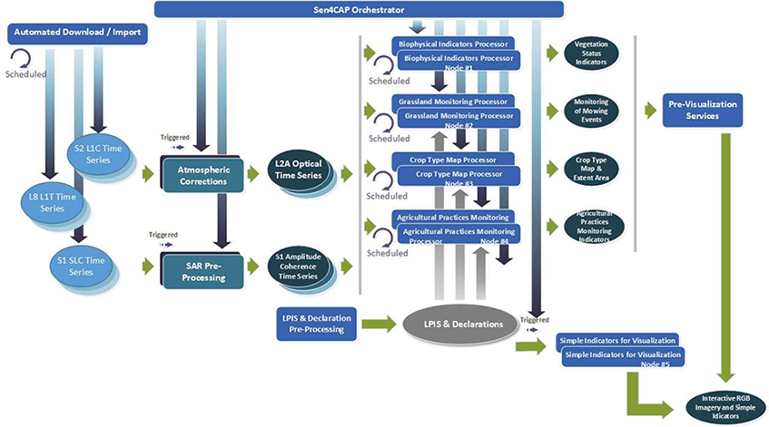
Figure 1: Operational workflow Sen4CAP system
Processor Details
- Version:3.2
- Input Data: Sentinel-1 and Sentinel-2
- Methodology: Detailed information can be found in the links below.
Access and Use
To use Sen4CAP an CODE-DE account with adequate resources is required. Several VM images with different versions of Sen4CAP are available featuring all additional software components required for Sen4CAP (e.g. PostgreSQL Database and the MAJA processor) execution. Furthermore, they are connected to the Sentinel-1 and Sentinel-2 data collections, which are needed by Sen4CAP. Different DEMs and SWBD (Water Body) data were also integrated.
Once logged into the VM, the user can immediately run the Sen4CAP software and benefits from both the direct access to the comprehensive Copernicus Sentinel satellite data repository. The VM with Sen4CAP can be accessed e.g. through a web browser or Remote Desktop using e.g. the X2Go Client.
To select the size (virtual machine flavor and storage) of infrastructure for the area you want to monitor, contact the support.
To set up a VM instance with a Sen4CAP installation, follow the instructions in the knowledgebase article "How to access Sen4CAP".
More Information
More information about this product can also be found on the following external pages:
References
The following list of references does not claim to be exhaustive, but it provides an initial introduction to the more detailed technical literature.




