
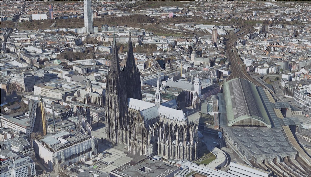
3D-Mesh - North Rhine-Westphalia (b3dm)
A 3D mesh is a textured representation of a 3D surface model created from aerial images. It depicts the terrain surface including vegetation, buildings and other man-made objects (e.g. parked cars). When calculating a 3D mesh, neighbouring three-dimensional points from the image correlation of the oriented aerial photographs are connected to form a network (mesh). The 3D mesh surface is then textured with the underlying aerial photographs with a ground resolution (GSD) of 10 cm.
Various types of 3D meshes are possible. The 3D mesh from Geobasis NRW is a 2.5D mesh. This means that only one elevation value is available for each 2D location coordinate.
Since the 2023 aerial survey, the 3D mesh has been derived by the Cologne district government – Geobasis NRW – as a standard product of the surveying administration. In order to achieve added value, promote innovative applications and the development of open source tools, and in particular to support current format issues in the product development of official surveying, a supplementary, state-wide data set is made available via the CODE-DE platform, which is based on long-standing standards and global spatial reference specifications. This test data set covers the entire state of North Rhine-Westphalia with an area of more than 34,000 km2 and was produced from data from 2023 and 2024.
Thanks to its realistic and photorealistic representation of the Earth's surface, the 3D mesh can be used in a wide variety of fields.
The present three-dimensional image material has the following characteristics:
- Spatial coverage: North Rhine-Westphalia
- Flight date: 2023-2024
- Geometric resolution (ground resolution): 10 cm
- Reference system: EPSG:4326 - WGS84
- File format: 3D tiles/ b3dm (lossy compressed - F10) and metadata csv. and shp.
- Delivery unit: Aerial survey areas
Overviews of the aerial survey areas can be found in the 3D mesh folder under ‘MeshAktuell.geojson’.
Usage requirements
- Registration on CODE-DE: yes
- Cloud resources on CODE-DE: yes
- Individual request: yes (to establish access)
Data access
This data is available upon individual request. Please create a support ticket to request the access data.
More information
Further information is available here on these external sources, among others:
- https://www.bezreg-koeln.nrw.de/geobasis-nrw/produkte-und-dienste/luftbild-und-satellitenbildinformationen/aktuelle-luftbild-und-5
- https://www.tim-online.nrw.de/tim-online2/?bg=basemapDE&scale=2649¢er=343766,5676529&icon=true
- dz.nrw.de
Please send any suggestions, comments and questions directly to geobasis(at)bezreg-koeln.nrw.de.
Terms of usage
The 3D mesh NRW (b3dm) is provided via the CODE-DE platform in accordance with open data principles and under the Data Licence Germany – Attribution – Version 2.0 (https://www.govdata.de/dl-de/by-2-0).
Note on source citation, in accordance with the Data Licence Germany – Attribution: When using the data, please ensure that the following information is included as a source citation:
- Name of the provider according to their specifications: 3D Mesh NRW (b3dm)
- The note "Data licence Germany – Attribution – Version 2.0" or "dl-de/by-2-0" with reference to the licence text at www.govdata.de/dl-de/by-2-0
- A reference to the data set (URI): CODE-DE
Example: 3D-Mesh NW (b3dm) / CODE-DE / www.govdata.de/dl-de/by-2-0




