

AICube
Joint Project of Constructor University (Project Lead), TU Berlin and rasdaman GmbH
Added value from Big Earth Data by combining AI and federated data cubes
Data cubes offer a natural, analysis-oriented view of spatiotemporal data that also scales very well. AI, on the other hand, improves the understanding of EO data with new methods. Interestingly, both techniques are based on the same mathematical foundations, namely tensor algebra.
The AI-Cube project explored how data cubes and AI-based analytics can be advantageously combined. The project team consisted of a partnership of Constructor (formerly Jacobs) University (project management), TU Berlin and rasdaman GmbH.

AI-Datacubes (source: rasdaman)
In AI-Cube, data cube fusion and AI-based analytics will be integrated, demonstrated in real-world application scenarios and installed on a federation of EO-LAB, DIASes and other large-volume EO/Geo data offerings. This should enable significantly better scalability and improved search, for example for the analysis of agricultural and forestry products and climate monitoring.
The team from TU Berlin has contributed an ML-based question-answer system that can answer questions in natural language. These can refer to the semantic content of the satellite images, such as "How many different types of grain occur in this Sentinel-2 multispectral image". The work was based on the BigEarthNet dataset from TU Berlin, which contains over 500,000 annotated Sentinel-1 and -2 scenes.
Recently, TU Berlin released ConfigILM, a pytorch-based library for configurable combination of pre-trained image and language models. More information can be found here.
Constructor University and the DeepTech SME rasdaman GmbH used the extensibility of the rasdaman Datacube Engine to incorporate ML evaluations. Analysis queries can call any model and apply it to territory that the user specifies. In the case of the TU Berlin models, the user also provides a natural language question. Internally, the data cube server calls the pytorch tool via its python interface, which applies the model and query to the image data provided and returns the result. This results in a seamless integration of ML and classical analysis together with the other rasdaman features such as GreenCube, cloud-native parallelisation, location-transparent federation and pixel-precise access protection.
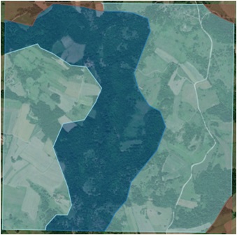
ML-based classification (source: TU Berlin)
All results were experimentally validated on EO-LAB. The prototypical integration has shown promising results in the laboratory and on real-world application scenarios. For the future, the use on DIASes and other large-volumeEO/Geo data offerings is planned. This should enable significantly better scalability and improved search, for example for the analysis of agricultural and forestry products and climate monitoring. At the same time, access protection can be set in such a way that the models can be used but not tapped.




