
CropHype
Improving field crop identification of western Kenya based on hyperspectral EnMAP data using Geo Engine
Smallholder agriculture makes a key contribution to the food supply of Southwest Africa. Environmental and climate change are increasingly threatening the agricultural yields and thus the livelihoods of smallholder farmers and the region's food security.
In a joint project of the Working Group on Climatology and Remote Sensing (LCRS) of the Philipps-University Marburg and the Geo Engine GmbH an important building block for solving this problem is being created.
The goal of the CropHype project is to use hybridized multispectral Sentinel-2 data and hyperspectral EnMap images to develop a model for intra-seasonal crop mapping for western Kenya. The model is intended to provide a foundation for reliable and up-to-date yield prediction models and contribute to improving food security.
The working group Climatology and Remote Sensing is in charge of the methodological development of the AI model. Here, methods of hyperspectral feature analysis, spectral unmixing, as well as image fusion methods and various machine learning approaches are used.
The Geo Engine is provided in the project as a data access platform and cloud service on EO-Lab. On the one hand, it ensures the provision, processing and processing of the hyperspectral EnMap data. On the other hand, it also provides a Sentinel-2 satellite data, other environmental models, and the project's own field field polygons. With the help of workflows, the various time series data can be pre-processed, combined and then streamed into training processes for machine learning. The goal of the project is to operationally integrate the trained models into the Geo Enigne and to make them available as a service.
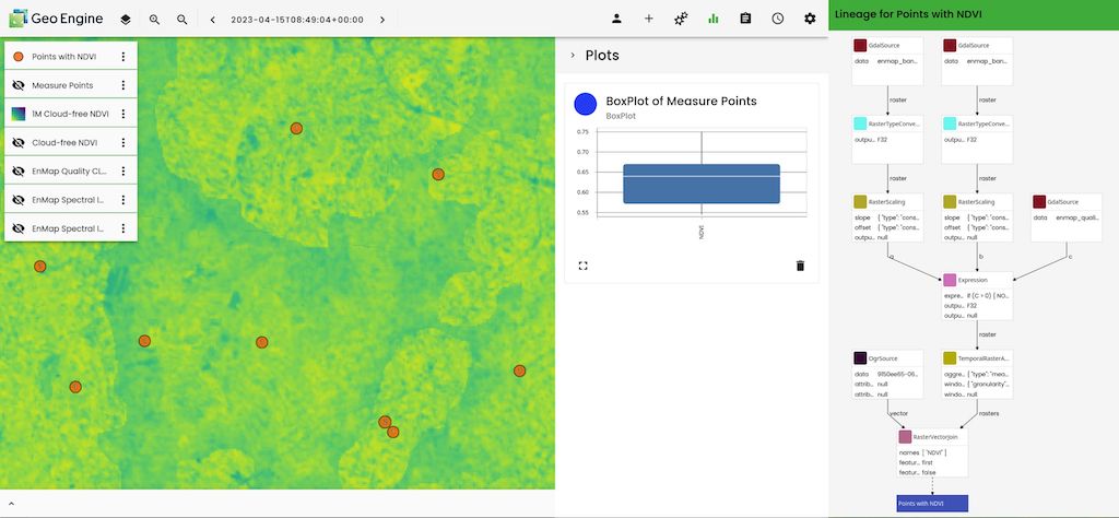
Example of a geo-engine workflow that calculates NDVI from EnMap data and links it to field centroids aggregated in time. This data is needed, among other things, for training the AI model.
For the collection of reference and training data in the field, the team cooperates with AgriBORA GmbH, which conducts data collection in direct collaboration with smallholder farms in Western Kenya and with the help of crowdsourcing.
More information
Further information on this product can also be found on the following external pages:
- Project homepage: https://uni-marburg.de/Gj2blR
- Geo Engine GmbH: https://www.geoengine.de
- AgriBORA GmbH: https://agribora.com
Image source
Photo: ©️ Dr. Sebastian Egli, AgriBORA GmbH.
Contains modified EnMAP data: ©️ DLR 2023




