
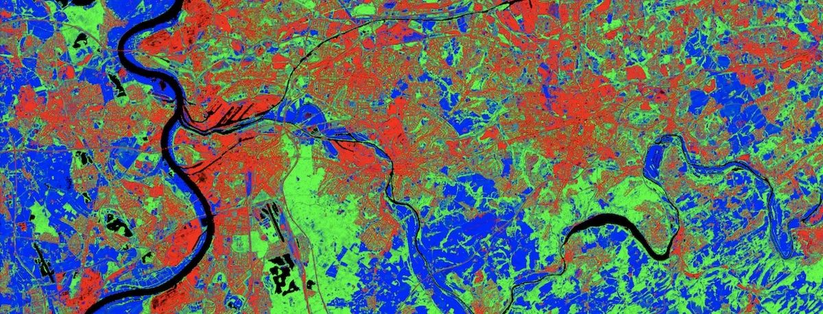
Land Cover Fraction Map (DE)
This raster map represents a classification of land cover based on sentinel data, showing the mixing proportion of land cover classes for each pixel. The classes 'built-up surfaces and infrastructure', 'woody vegetation' and 'non-woody vegetation' are distinguished.
The detailed investigations of land cover based on remote sensing data are part of the research work of the 'Humboldt-Universität zu Berlin' and represent another building block for a better understanding of the status and development of land cover, especially in the settled area.
The raster map 'Land Cover Fraction' is based on the Sentinel-2 and Sentinel-1 data of 2018 and is available in a resolution of 10m for the whole of Germany. Only settlement areas and infrastructures above a terrain height of 1,350 m are excluded.
The classification distinguishes between the land cover classes 'Built-up surfaces and infrastructure', 'Woody vegetation' and 'Non-woody vegetation'. The class 'Woody vegetation' includes for example hedges, avenue trees, forest, bush vegetation or plantations. Grassland, meadows, pastures, dikes and arable land are grouped under 'Non-woody vegetation'.
The classification is provided in a 3-channel raster data set. Thus, the proportions of all classes considered can be represented per pixel. The red channel represents the share of the class 'Built-up surfaces and infrastructure', the green channel the share of 'Woody Vegetation' and the blue channel the share of 'Non-woody vegetation'.
- Band 1: Built-up surfaces and infrastructure (Red)
- Band 2: Woody vegetation (Green)
- Band 3: Non-woody vegetation (Blue)
This raster map has been created using a regression-based unmixing approach. Spectral-temporal metrics from all Sentinel-1 and Sentinel-2 observation in 2018 have been used to create synthetically mixed training data for regression. An elevation threshold of 1350 m has been applied above which built-up surfaces and infrastructures were masked out. The mapping workflow has been established in the corresponding publication, see More information below.
Compared to the original data set described in the above-mentioned literature, the procedure for this now available version of the data set was supplemented by the following set of spectral-temporal metrics:
- 25th, 50th and 75th quantile of Sentinel-2 reflectance
- Average Sentinel-1 VH polarized backscatter
- 90th quantile and standard deviation of Sentinel-2 Tasseled Cap Greenness
This enhanced set makes use of Sentinel-1 imagery, which reduces confusion of built-up features and seasonal soil-covered surfaces. Sentinel-2 Tasseled Cap Greenness is a more robust indicator for vegetation in temperate regions than the NDVI, which was used in the corresponding publication.
Availability
- Germany: Complete coverage
- Europe: -
- Global: -
Access
Depending on the environment and the intended use, there are several ways to access the data:
- EO Browser:
- Community Contributions --> Land Cover Fraction Map (GE)
- Data Explorer: -
- Path to repository on a Virtual Machine:
- /codede/community/GLC_Germany_2018
Acknowledgement
- Sentinel-1 data was kindly provided by TU Vienna through EODC.
- This research has received funding from the European Research Council (ERC) under the European Union's Horizon 2020 research and innovation programme (grant agreement No 741950).
More information
Further information on this product can also be found on the following external pages:
Terms of use
Use of the product is subject to the following terms of use:
References
- Schug, Franz; Frantz, David; Okujeni, Akpona; van der Linden, Sebastian; Hostert, Patrick (2020): Land cover fraction map of Germany at 10m spatial resolution based on Sentinel-1 and Sentinel-2 spectral temporal metrics. PANGAEA, https://doi.org/10.1594/PANGAEA.920894




